Sunday, August 23, 2015

High Point # 6 - Mt. Mansfield, Vermont

Hi and welcome back!


At the beginning of summer, my family and I went on a vacation to Waterbury, Vermont.  While we were there, my dad and I climbed the high point in Vermont, Mt. Mansfield.  Mansfield is 4,393', and it's part of the Green Mountains.


The high point is located in Underhill State Park, so we had to drive about an hour from the hotel to the trailhead.

When we got to the trailhead, it was drizzling, and although we thought the climb would be an hour to an hour and a half round trip, the ranger said it would take more like five hours.  


Because we only had t-shirts on, and hadn't brought rain gear, we decided to go to Burlington instead and climb the next day.

The next day, it was around 80 degrees, and sunny (the only sunny part of the whole trip, it would turn out).  We started the climb midmorning, and took the Sunset Ridge Trail.  It was steep, rocky, and still very wet from the rain the previous day and the many streams that flow down the mountain.


We climbed through the woods for about 45 minutes, then came out to see a view of the summit ridge.


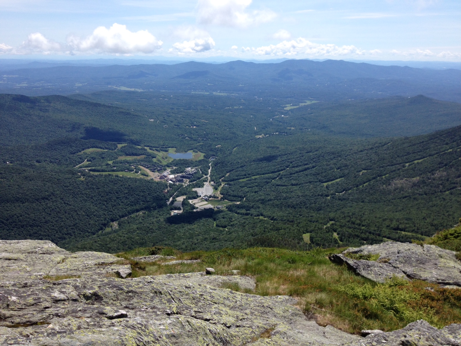
Right after we came out of the woods, there was a great rock outcropping, and we could see  about 50 miles across Lake Champlain and the border into Canada!


From there it wasn't quite as steep as the trail in the woods had been, and after 2:02 of climbing, we got to the summit.


Stowe Ski Area, as seen on the far side of the mountain.


For the descent, we decided to take the Laura Cowles trail, which was more technical, but would shave some distance off the total.


What we didn't realize was that the Laura Cowles trail was even steeper, rockier, and wetter than Sunset Ridge.  We really had to take our time, and we slipped in a few places, but thankfully we were holding onto trees and roots as we were jumping from rock to rock.


Even though we stopped to talk to some people on the descent, we decided that we wanted to finish in under four hours.  We were just about running the last few hundred yards (once it was almost level), and our total time was 3:58:30!


Be sure to check back soon, when we add our post about the latest twofer in Connecticut and Rhode Island!

Thanks for reading!

Monday, January 12, 2015

Happy 2015!

Hi and welcome back!
Unpacking Breakfast

On Christmas eve, dad and I did our annual knife edge hike, although this year it was rainy and mild.  We left the house around 6:00 a.m. and got to the trailhead at 6:30.  We reached knife edge at 7:30 and tried to use the Esbit pocket stove, which is little more than a two-sided windscreen that holds a pot.

It was windy when we got to the ridge, and we couldn't keep a match lit long enough to start the fuel cube.  So we didn't get to have breakfast on the ridge, but it was an adventure!

The next day, on Christmas morning, for the second time I got a tent!  It's the Marmot Ajax 3-person, and I slept in it that night.  I have to say that it's better than the Alps, and a lot roomier and more comfortable than the REI minimalist bivy that I've been using for the last year or so.

The Ajax

My brother, sister, and I each got some cool rock holds for Christmas, too.  Mine included a leaf, a pine tree, and there were also an acorn, a tennis ball, and a few others.  I can't wait to get them up on the rock wall.


On New Year's Day, Dad and I made our hike part of our first-ever "polar bear plunge"!  We joined about 20 other people and walked from a friend's house to a swimming hole in the Mahoning Creek.  After breaking through the crust of ice on top of the water, about 15 of us waded in, held our breath, and dunked ourselves under the water.

It was...interesting.  My feet went numb almost immediately when I stepped into the water, and it took me about 30 seconds to get into deep water and submerge myself.  After that I waded out and dried off as quickly as I could!  The air temperature was about 37, which was good, but there was a little wind.  The walk back was really, really cold, but we had a great time!

Thanks for reading!


Monday, October 20, 2014

The Climbing Wall is Up!


Hi and welcome back!

As you can see from the title, the rock wall is now done!  It's about 12.5 feet tall, there are two sides with holds that come to a dihedral (there will eventually be two more) and we even put a chimney in one of the corners.

We started working on it in early September, and it took about four weekends.  We would have never gotten it done so well if it was just my dad and me.  Luckily, our friend Jesse Straussberger, who I've been working for since springtime, made it possible.  Here are a bunch of step-by-step pictures.


Drilling the first of the 4-foot deep holes for
the 16'x6"x6" posts


Posts in and supported. The sides are both 8' long 

The 2"x6" studs for the plywood sheets.


Painting the plywood sheets.  We used a
special paint with sand in it that looks and feels like rock.


Sorting the holds before placing them on the plywood


Figuring out the routes

Jesse hanging the plywood sheets on the studs

All done!  Here I am getting ready to climb
one of the first times...in the rain.

My friend Cassidy in the chimney

My friend Tate getting ready to climb


Climbing in my back yard!


My dad took the video above of me climbing on the overhung route one of the first times.  I hung a cowbell at the top so you can ring it when you get all the way up.

I have to thank Jesse again for his help.  He came up with a really cool design, and then was able to make a real thing! 

I'd also like to welcome our new visitors from France.  I've noticed that a lot of people have been reading from France in the last few weeks, and I'm glad you're stopping by!

Thanks for reading!


Saturday, August 2, 2014

High Point #5!

Hi and welcome back!

A few weeks ago, my family and I went to New Jersey to climb the high point--which is called High Point.  It's in the northwest corner of the state, and it's only about two hours from where we live.

It was a warm day, but it wasn't too hot, and it was sunny, so it was a perfect day to hike.


Jed looking for bears


We took the Monument Trail, which was supposed to be 3.7 miles in all. We started out with all of us walking in the wrong direction, because my dad wasn't really paying attention, and the trail wasn't well marked.


We walked for about 20 minutes in the wrong direction before we asked a through hiker coming in the opposite direction if he had seen the high point.  He said he hadn't, which meant we were going the wrong way.


Almost there?


After about an hour of hiking, we got to a clearing and could see the summit obelisk.  It looked like it was about an hour away, but it only took a half hour from that point.


Edie and me


In all it took us about an hour and a half to get to the summit, and then dad and I hiked back to get the car.  We drove back to pick up mom, Edie, Jed, and Maisy so they didn't have to walk all the way back.


Jed was a real trooper.  He only had to go on my dad's shoulders for about fifteen minutes.

This week I'm going to do another presentation on my year in the tent and Yosemite climb.  But this time it's going to be at my old elementary school, and I will have another post on that and my new tent sometime soon.


Thanks for reading!

Monday, July 7, 2014

Mt. Washington Post #2


Hi and welcome back!

Reading Camp Presentation
Before I get to my Mt. Washington climb, I want to tell you about a presentation I did two weeks ago.  I was invited to speak at a nearby town's elementary school reading camp!

I put together a slide show of pictures from my year in the tent and my Royal Arches climb, and also the Royal Arches video. I also set up our family's L.L. Bean tent that I spent the last few weeks of 2013 in.

It was a lot of fun, and I want to thank Ms. Robins for inviting me to give the presentation!


Now on to my Mt. Washington climb.

My dad and I started at Pinkham Notch Visitors Center at about 9:45 a.m.  For over half of the 4.2 mile ascent, we were climbing a pretty steep, REALLY rocky trail.  It was pretty hard on our knees.

After that, we took a turn where the Lion’s Head trail comes off the Tuckerman Ravine trail.  From there it was scrambling in fairly thick woods.  That led us above treeline.


Next we started climbing up Lion’s Head, which helps form the Tuckerman Ravine.  We then descended a tiny bit from Lion’s Head and spent about an hour scrambling in the open up to the summit!  It was just about four hours to the top.


We took a few pictures at the summit sign, then went into the visitors’ center and got lunch.


We descended the Tuckerman Ravine trail, which actually goes down into the ravine, then connects with the main, steep, rocky trail.

We started the descent on the same scramble we had just climbed up (the Lion’s Head and Tuckerman Ravine trails are the same there).  Then we continued into the ravine.  It was VERY steep, and we had to switch back down the trail, which was only about 6 feet wide in places.

Part of the way down the ravine, we ran into some snow that was at about 5,000’.  Meltwater had hollowed the snowfield out underneath, and there were caves that were big enough to crawl into (although that would have been dangerous).


From there we continued down onto the rocky trail again, which took us back to the visitors’ center at Pinkham Notch.  It was just about 8 hours round trip, and REALLY tiring.

I think our next high point will be New Jersey, but first we’re hoping to do some climbing outside!

Thanks for reading!


Saturday, June 28, 2014

Mt. Washington, Post #1

Hi and welcome back!

As some of you probably know, tonight is the Great American Campout. I don't have any friends over, though, because we're getting ready to go to New Hampshire and climb Mt. Washington.

Mt. Washington is the highest peak in the northeast at 6,288 feet tall. My dad and I climbed Mt. Washington three years ago when I was eight, but we drove down so I won't count that ascent for my 50 Highest project.

If my dad and I summit, I'll do a follow-up post with the details of the climb.

Thanks for reading!

Monday, May 26, 2014

Hi and welcome back!

Fishing the Mud Run
Brook Trout in the Mauch Chunk Creek
Two weeks ago, my dad and I went fly fishing on the Mud Run Creek in the Pocono mountains. Neither of us caught anything, but I hookedan 11-inch brown that broke my line right before we got him in the net. He then swam away with a White Wulff fly stuck in his mouth. Thankfully, one of our friends said that the fly would rust out of his mouth eventually.


Today my dad and I went fly fishing once again, but this time in the Mauch Chunk Creek. This time I caught an 8-inch brook trout, which we were able to get in the net.  Dad texted a picture to my teacher Mr. Rabenold, who we saw at the Memorial Day parade this morning, and he said that with a few more I would have a tin of sardines...


Thanks for reading!


Sunday, May 4, 2014

Banff Mountain Film Festival

Hi and welcome back!

Last Sunday my dad and I went to the local screening of the Banff Mountain Film Festival. All of th
e films were great.


I especially liked The Questions We Ask, which was about Bruce Kirkby crossing the Pacific Ocean on a stand-up paddle board. During the film he was posing questions through his narrations about why we do things in life. This film put the thought of "Why sleep in a tent for a year?" in my head, and to be honest I don't know why. Thank you, Mrs. Decker, for telling us about the film festival!

Yesterday for our hike, my dad and I went fly fishing. This was my first time trying it, and I was really excited.  The spot where we were going to fish had about a 30 minute hike in, but when we got about 20 minutes in we hit really thick thorn bushes, and we didn't want to go through. That meant that we forced to fish there.


We had a lot of rain last week, so the creek was really high, really fast, and really muddy, which made fishing too hard. Plus, there were a lot of trees around us, so I took about ten casts, lost five flies, and caught zero fish.

"In the Wilderness?"
When we were hiking out my dad asked if I had fun, and I said yes. He said he was afraid I would never want to go again, but if I had fun yesterday, I would love it when conditions are better!

Today my dad, little brother, and I went for a hike. My little brother told me to say that he had fun and that he likes hiking.


When my dad took this picture, Jed (my brother) asked if it looked like he was in the wilderness.


Thanks for reading!


Tuesday, April 29, 2014

Epic Hike - for School!


Hi and welcome back!
Mr. Rabenold


On Easter weekend we had an extra credit hike for school.  We hiked up Mount Pisgah near Jim Thorpe, which is pretty much the biggest hill in the area.  

About 50 people showed up, which I thought was a lot for a Saturday on a holiday weekend. 

My social studies teacher, Mr. Rabenold, started out by telling everyone about the history of Jim Thorpe and the Switchback Railroad, which we would be hiking along.

We started on a fairly short, yet steep switchback trail that ended at the top of Mt. Pisgah with an awesome view.  We could even see a few miles out to a waterfall in the distance.


At the top of Mount Pisgah with C.S. and C.S.
After that, we went on a long, slightly downhill trail. While on that trail, we saw the first known coal mine in North America. It wasn't much to see, though, because it was small and overgrown.


The Mine Entrance

The coolest part was when we had to walk across a 100 foot section that was only about a foot wide, and if you fell, you would fall/slide for 25 feet.  Luckily, no one fell.  The rock face was about 75 feet high, and it was a steep slab above the trail and to the right.  Dad, C.S. and I decided we're going to come back with our rope and try to climb it.


Inside the Mine


At the bottom of that last section was another abandoned coal mine that we all went into. Mr. Rabenold,  wasn't sure if there were any vertical shafts, so we weren't supposed to go too far into it. But my dad and I are going to come back and go deeper with headlamps to see what we can find.


Thanks for reading!


Sunday, April 13, 2014

Great Hikes!

Hi and welcome back!


The answer to last week's trivia question is Dick Bass.  He was the first person to climb the seven summits.

Yesterday (Saturday) my dad and I hiked to the Mahoning Creek. The creek is in the opposite direction of the pond, and my dad used to fly fish there. Lately, I've been getting into fly fishing, so we decided to go and check it out. While we were there Maisy decided to go swimming. She swam about 1/3 of the way across the creek and then decided to turn around and come back.  I could tell she had a lot fun.


Panoramic Shot of the Creek


Today I had a soccer tournament, and afterward dad and I hiked a spot where he climbed about 15 years ago.  The hike in was...interesting.  We had to do a bit of trespassing, we bushwhacked through some really thick thorns (my legs still hurt), and then we found it.


Wishing I had my Rope!


The wall was about 40 feet high, and the few minutes of bouldering that I did made it seem like the climbs ranged from 5.6 to about 5.10.  The rock was very strange.  It was broken up into squares and sections on the wall, but it wasn't loose.  You could definitely climb safely on it.  I know this, because we found almost brand-new bolts on at least a half dozen routes.  This means that in a few years when I start lead climbing, I can go out there and sport climb.


Taken by Mom


My dad is a business writer, and he has an office in an outbuilding out in a corner of our yard.  A  few days ago, I came home from school, and I was climbing on the tree right next to it.  Then I decided to go up on his roof.  Mom took a picture of me, and I thought it turned out well!


Thanks for reading!